According to the U.S. Geological Survey (USGS) and the European-Mediterranean Seismological Centre (EMSC), the quake occurred at 7:37 a.m. local time in the waters south of Mindanao Island.
The USGS reported that the epicenter was located approximately 60 kilometers south of General Santos City in South Cotabato province, at a depth of 55.2 kilometers. The EMSC initially recorded the earthquake at a magnitude of 8.1 before revising it to 7.8.
The Philippine Institute of Volcanology and Seismology identified the epicenter as being about 32 kilometers southwest of the village of Maasim in Sarangani province, with a depth of 33 kilometers. Following the initial quake, several strong aftershocks, including one measuring 6.5, were reported, with tremors felt as far away as Malaysia.
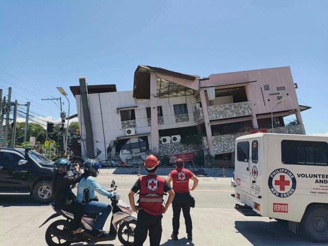
According to the Associated Press, at least 12 people have died and more than 200 have been injured, primarily due to collapsing buildings.
The damage was concentrated in General Santos, a port city with a population of over 700,000. Rod Sosemeña, a regional director of the Philippine National Disaster Risk Reduction and Management Council, reported that at least seven people died and around 130 were injured in General Santos. Some small buildings collapsed, and several structures, including key access bridges, sustained dangerous cracks.
As a result of the earthquake, General Santos International Airport was temporarily closed, and 17 domestic flights were canceled. An additional five fatalities were reported in South Cotabato, Davao Occidental, and Balut Island.
A tsunami was also observed along the nearby coast following the earthquake. The Pacific Tsunami Warning Center stated that the tsunami threat had mostly passed about five hours after the quake. Teresito Bacolcol, head of the Philippine Institute of Volcanology and Seismology, reported no damage or casualties from the tsunami so far.
Waves of up to one meter were recorded in Sultan Kudarat and Sarangani provinces. An 83-centimeter tsunami was measured off the coast of Sulawesi, Indonesia, prompting the Malaysian Meteorological Department to issue a tsunami warning for Sabah on Borneo.
The Philippines is located in the Pacific Ring of Fire, an area prone to frequent earthquakes and volcanic eruptions. It is also considered one of the most disaster-prone countries, affected annually by about 20 typhoons and tropical storms.
* This article has been translated by AI.

Copyright ⓒ Aju Press All rights reserved.