Naver announced on June 19 that it has launched a real-time walking navigation service, enhancing convenience with the addition of voice guidance. The navigation's safety features have also been improved.
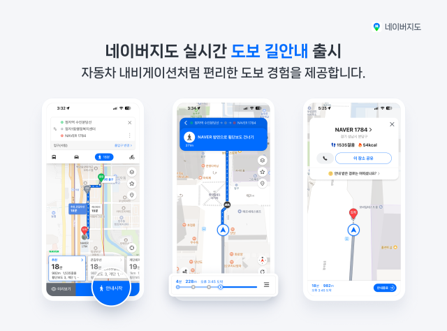
The real-time walking navigation service allows users to receive route guidance without checking their smartphone screens while walking. This service is currently available on Android devices, with plans to roll it out on iOS in the future. Naver Maps has been enhancing its walking navigation services, including a walking follow feature in 2023 and a stair avoidance route in 2024.
The real-time walking navigation is integrated with public transportation route finding. It provides users with guidance from their starting point to public transport boarding and alighting points, and finally to their destination. The navigation screen also displays information about the next bus or subway line to take, along with estimated arrival times.
This service is connected to the augmented reality (AR) navigation service that was initially applied at COEX last year. Users can continue receiving AR navigation guidance when they enter designated AR navigation areas.
Additionally, Naver has revamped the user interface and experience of Naver Maps to allow navigation users to easily report road conditions while driving. A 'Report' icon has been added to the navigation guidance screen, enabling users to quickly report unexpected situations such as accidents, construction, or road closures. These reports are shared in real-time with other drivers.
The navigation features have also been upgraded. Users will receive real-time alerts about speed cameras and variable speed enforcement cameras. In 'Safe Driving' mode, which allows for driving without a specific destination, users can also check real-time traffic light information.
In May, Naver Maps recorded an average of over 31 million users per day, marking a double-digit growth rate for four consecutive years since 2022. The company continues to enhance related features to support safer travel experiences. Real-time information on accidents and road closures has also been strengthened. In April, Naver collaborated with the Financial Supervisory Service to enhance warnings about areas with frequent intentional accidents.
Naver is also working to strengthen its place-based services, including customized services based on actual veterinary clinic data.
Jung Kyung-hwa, the leader overseeing Naver Maps services, stated, "Naver Maps is an all-in-one platform that supports users throughout their journey. With this update, we have strengthened the integration and guidance between walking and public transportation, enabling more convenient and precise travel. Naver Maps will continue to enhance its services to ensure over 31 million users can travel more conveniently and safely to their final destinations each month."
* This article has been translated by AI.
Copyright ⓒ Aju Press All rights reserved.