Ho Chi Minh City is set to shift from its traditional administrative policies to a watershed management system to tackle flooding and wastewater treatment issues. This long-term strategy aims to address both flood prevention and environmental improvement in response to climate change and urban expansion.
On June 23, local media, including Thanh Nien News, reported that the city's Department of Construction has begun gathering input from relevant departments and agencies to draft a plan for flood prevention and wastewater treatment from 2026 to 2060.
According to the Department of Construction, the current drainage and flood control plans, approved in 2001 and 2008, are outdated and do not reflect the rapidly changing urban environment. The existing flood response strategies were designed for the pre-merger administrative boundaries of Ho Chi Minh City, making it urgent to develop new measures that align with the city's expanded size.
Recently, Ho Chi Minh City has integrated with Binh Duong and Ba Ria-Vung Tau provinces, creating a massive urban area that combines industrial, service, and port functions. However, the significant differences in topography, hydrology, and urbanization levels across regions have highlighted the limitations of the existing management approach.
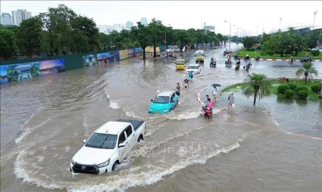
Currently, there are 159 locations across the integrated city that experience frequent flooding. Of these, 76 are in the former Ho Chi Minh City area, followed by 52 in Binh Duong and 31 in Ba Ria-Vung Tau.
Moreover, heavy rainfall has increasingly exceeded design capacities. Tide levels at the Phu An and Nha Be monitoring stations have surpassed 1.8 meters, setting new records. Ground subsidence, rapid urban development, and the filling of reservoirs and wetlands have further weakened natural drainage capabilities.
Environmental issues are also a major concern. The integrated urban area generates approximately 1.97 million cubic meters of domestic wastewater daily, but the current treatment capacity is only 340,000 cubic meters, or 17% of the total. As a result, a significant amount of wastewater flows directly into the Saigon River, Dong Nai River basin, and coastal areas.
However, the Department of Construction noted that some progress has been made through ongoing projects. Flood response initiatives have improved flooding issues on major roads such as Tan Quy, Truong Cong Dinh, Ba Van, Bau Cat, and Nguyen Huu Can. Additionally, the first phase of the tidal flood prevention project is 93.33% complete.
The second phase of the Binh Hung wastewater treatment plant project has increased treatment capacity to 469,000 cubic meters per day. The expansion of the Nieu Loc-Ti Nghe wastewater treatment plant is also underway. Furthermore, digital technologies, including a flood reporting platform and a GIS-based drainage management system, have been introduced.
Despite these efforts, the Department of Construction assessed that existing methods have been limited to addressing individual flooding points and lack a comprehensive risk management system. The new plan will focus on managing upstream areas, low-lying urban centers, and coastal regions as a single watershed.
A key aspect of this strategy is to analyze flood risks and develop response strategies based on drainage basins rather than administrative boundaries. This approach is expected to provide a more accurate understanding of water flow, bottlenecks, and the spread of flood impacts.
The new strategy will operate under the principles of 'conservation, retention, and drainage.' It aims to enhance existing infrastructure such as drainage pipes, levees, pumping stations, and wastewater treatment plants while also actively utilizing nature-based solutions like retention areas, permeable spaces, canal restoration, and the creation of ecological buffers.
Additionally, non-structural measures will be included, such as establishing a GIS database, operating an early warning system, managing illegal encroachments on drainage pathways, and improving public awareness. The city is also reviewing 2 to 3 operational models to develop a flood response coordination system suitable for a large metropolitan area.
Ho Chi Minh City is currently refining its plans in collaboration with Dutch partner organizations and will gather input from relevant departments by the end of this month. As a short-term measure, the city plans to develop a separate flood mitigation plan for 2026-2030, prioritizing improvements in areas with significant resident inconvenience.
* This article has been translated by AI.
Copyright ⓒ Aju Press All rights reserved.